Eyes on the risk
By Lee Elliston, Claims Director
Adjusting claims is a knowledge business. For insurers to pay claims quickly, they need to know what’s happening on the ground, but gaining knowledge can be a real challenge. Distance and inaccessibility can make getting eyes on the risk very difficult, especially in the wake of a major catastrophe.
For Lloyd’s managing agents, and their delegated parties (specifically TPAs), the market's new high-tech satellite imagery and intelligence service makes it easier and faster to get ground truth – and therefore to pay valid claims as fast as possible. That makes insureds into satisfied, repeat customers.
Recent catastrophic events have proved that the new system for the Lloyd's market works. By combining detailed satellite imagery and radar, as well as CCTV and drone footage, weather databases, social media posts, and local news broadcasts, the service provides managing agents with damage data at an individual property level in the immediate aftermath of a catastrophe. That enables Lloyd’s managing agents to assess damage from major claims event events far quicker than was ever previously possible.
The service was first used successfully in the wake of hurricanes Harvey, Irma, and Maria last year, just after its launch. It has now been enhanced, with further developments in the pipeline. Version 2, which went live in the summer of 2018, now includes a geocode search tool, and new desktop views that enable managing agents to find an insured property fast, and therefore to make a remote adjustment decision almost immediately.
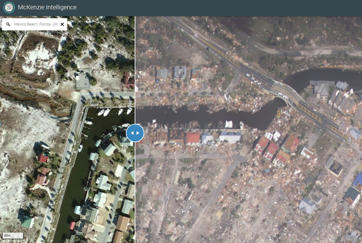
Users can now compare pre and post-loss images to assess damage. The latest version also splits out data into 24, 72, and 168 hour views specifically tailored to the needs of underwriters, claims professionals, and reinsurance teams. Supplied by McKenzie Intelligence Service (MIS), the enhanced facility was activated to provide real-time information about hurricanes Florence and Michael, and this year’s series of US wildfires. Again it proved its worth, proving particularly valuable for wildfire claims, since it quickly allows underwriters to literally see if an insured property has been destroyed.
All Lloyd’s managing agents are now registered to use the system. At present each insured risk must be searched for and compared manually, one at a time. However, that is soon to change. The next enhancement will incorporate a pre-loss capability that will allow managing agents to upload in advance all the location details of their insured properties within an entire portfolio. That will allow the MIS system to prepare a single report of damaged properties across the piece within days of a catastrophe.
Longer term, MIS plans to tap into the Internet of Things and to incorporate data from connected sensors. For example, sensors in unattended buildings in catastrophe-exposed locations – such as coastal holiday homes in southern US states – could inform insurers and property owners of potential flood damage. This could trigger mitigation actions, as well as help with the problem of loss creep, where insurers are notified of a specific loss only well after an event.
InsurTech is challenging and improving the way global insurance markets do business. The LMA’s satellite imagery and intelligence service is one way Lloyd’s is using disruptive technology to enhance its service to customers around the world, by allowing underwriters and adjusters to get eyes on the risk faster than ever before.
IMAGE: A new feature of the McKenzie Intelligence Service is a pre and post-event slider tool enables insurers to quickly find an insured property and assess damage.
|